Breaking News

Western Digital Accelerates Storage Innovation for AI Era Leica LUX Case for the iPhone 17 Pro/Pro Max ASUS Announces ROG Strix Aiolos Viltrox Launches AF 16mm F1.8 L for Full Frame Casio to Release G-SHOCK with Minimalist Metal Design and Even Better Fit

logo

  • Share Us
    • Facebook
    • Twitter
  • Home
  • Home
  • News
  • Reviews
  • Essays
  • Forum
  • Legacy
  • About
    • Submit News

    • Contact Us
    • Privacy

    • Promotion
    • Advertise

    • RSS Feed
    • Site Map

Search form

Apple to Enhance Mapping With Own Data, Satellite Imagery, and Data from iPhone Users

Apple to Enhance Mapping With Own Data, Satellite Imagery, and Data from iPhone Users

Smartphones Jun 30,2018 0

Apple is rebuilding the mapping application on its iPhones from the ground up with its own dataset gathered by camera-and-LIDAR-equipped trucks, satellite imagery, and anonymized data from millions of iPhone users.

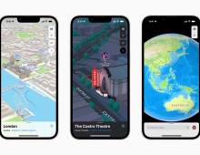
Until today, Apple Maps were using data provided by Amsterdam-based TomTom NV. Apple said that the new Maps, which will start the rollout this fall for the Northern California territory, will continue to use data from TomTom, enhanced with data gathered by its own fleet of sensor-equipped vans and with anonymous data from iPhone users that choose to share it.

The new Maps will be more accurate, more reliable and more rapidly updated , since they will use data from future iPhones, which are said to have location data accurate to less than one meter (GNSS).

Apple plans to use a variety of techniques, including segmentation, to pull location data from hundreds of millions of iPhones without violating users' privacy.

Adding to maps a layer of Augmented Reality will also result in new experiences, from measuring objects to playing multiplayer games. You could ask your phone for recommendations of a good place to get lunch nearby, and when you hold up your phone, restaurant rating cards are superimposed over the real world, each one precisely located right where the restaurants are. Or even get directions with data superimposed onto the real world.

Tags: Apple Maps
Previous Post
Facebook Handed User Data to Apps, Others
Next Post
ZTE Revamps Chairman and Board to Avoid U.S. Ban

Related Posts

  • Apple Maps introduces new ways to explore major cities in 3D

  • Apple Redesigns the Maps App

Latest News

Western Digital Accelerates Storage Innovation for AI Era
Enterprise & IT

Western Digital Accelerates Storage Innovation for AI Era

Leica LUX Case for the iPhone 17 Pro/Pro Max
Cameras

Leica LUX Case for the iPhone 17 Pro/Pro Max

ASUS Announces ROG Strix Aiolos
PC components

ASUS Announces ROG Strix Aiolos

Viltrox Launches AF 16mm F1.8 L for Full Frame
Cameras

Viltrox Launches AF 16mm F1.8 L for Full Frame

Casio to Release G-SHOCK with Minimalist Metal Design and Even Better Fit
Consumer Electronics

Casio to Release G-SHOCK with Minimalist Metal Design and Even Better Fit

Popular Reviews

be quiet! Dark Mount Keyboard

be quiet! Dark Mount Keyboard

Terramaster F8-SSD

Terramaster F8-SSD

be quiet! Light Mount Keyboard

be quiet! Light Mount Keyboard

Soundpeats Pop Clip

Soundpeats Pop Clip

Akaso 360 Action camera

Akaso 360 Action camera

Dragon Touch Digital Calendar

Dragon Touch Digital Calendar

be quiet! Pure Loop 3 280mm

be quiet! Pure Loop 3 280mm

Noctua NF-A12x25 G2 fans

Noctua NF-A12x25 G2 fans

Main menu

  • Home
  • News
  • Reviews
  • Essays
  • Forum
  • Legacy
  • About
    • Submit News

    • Contact Us
    • Privacy

    • Promotion
    • Advertise

    • RSS Feed
    • Site Map
  • About
  • Privacy
  • Contact Us
  • Promotional Opportunities @ CdrInfo.com
  • Advertise on out site
  • Submit your News to our site
  • RSS Feed